
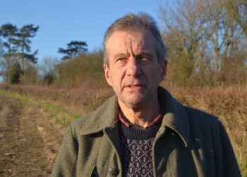
CAMPAIGNERS who have been working hard to keep a much-loved Frome riverside path open, have been surprised and relieved to find the path has now been shown as a public right of way on the area’s latest Ordnance Survey map.
The Save Wallbridge Adderwell Path group (SWAP) was set up earlier this year to oppose plans by an out of town developer to fence off the area for his private use.
The latest OS online map shows the Wallbridge to Adderwell path clearly marked (with green dotted line) as a right of way following exactly the route that local people have walked for 30 years and more.
“This simple right to continue to walk the path is exactly what we’ve been campaigning for,” said Simon Keyes, chair of the Save Wallbridge Adderwell Path group.
1,700 local people have signed a petition in support of the campaign which is fully backed by Frome Town Council and by organisations such as Friends of the River Frome, the Civic Society and Frome Recreation and Open Ground Supporters (FROGS).
“There’s plenty of evidence that this path is already a right of way” says Simon, “but we weren’t expecting the formal recognition quite so soon. Naturally we’re delighted to find that it’s now on the map and hope it stays that way. We’ve asked the landowners to remove the obstructions they’ve put up”.
Somerset County Council also expressed surprise that the path has appeared on the map and have said they will look into the matter.


 with former Chair Yvonne Kirby")


